 NIB - MORSKA BIOLOŠKA POSTAJA PIRAN
Copernicus Marine User Engagement
Developing High-Resolution Models for Forecasting Sea Surface Currents and Marine Effluent Dispersion

 |
 |
The project Copernicus Marine User Engagement is worth 100.000 eur.
MERCATOR OCEAN shall finance this contract by means of European funds (Regulation No 2021/696 of the European Parliament and of the Council of 28 April 2021 establishing the Union's space programme and the European Union Agency for the Space Programme and repealing Regulations (EU) No 912/2010, (EU) No 1285/2013 and (EU) No 377/2014 and Decision No 541/2014/EU).
Research organization: National Institute of Biology, Marine Biology Station Piran
Research collaborator: Slovenian Environment Agency of the Ministry of the Environment, Climate and Energy
Project leader: Boris Petelin, PhD
Partners: Martin Vodopivec, PhD,
Matjaž Ličer, PhD,
Branko Čermelj, PhD
Duration: 05.07.2023 - 05.01.2025
Summary of the project:
The Gulf of Trieste is the northernmost part of the Mediterranean and Adriatic Sea. This is a location of intense marine traffic, tourism, and fishing. The Gulf of Trieste is home to two of the most important ports on the Adriatic coast: Trieste, which handled a total of more than 55 million tons of cargo in 2021, including more than 750,000 container units, and Koper, which handled nearly one million container units and a total of 23 million tons of cargo in 2021.
The goal of the project is to develop high-resolution operational numerical models for operational forecast of the distribution of sea surface currents and the dispersion of wastewater from the sewage treatment plant into the sea:
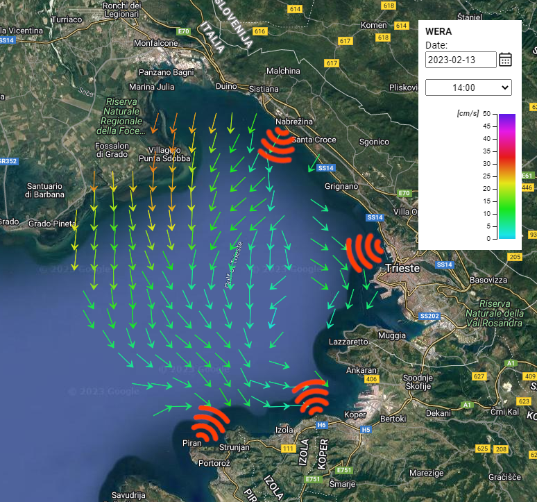
1) Copernicus Marine Use Case 1 - predicting the distribution of surface currents in the Gulf of Trieste (northern Adriatic Sea) to complement measurements from three HF radars stationed in the Gulf of Trieste. The radar provides current measurements in 30 min intervals except during maintenance and occasional technical malfunctions. In some areas, there are also occasional outages and unreliable current measurements, therefore high-resolution model currents would add complementary value. The three-day half-hourly forecast of sea currents, provided by our model, will be displayed on the web page along the HF radar measurements. An example of such measurements is shown in Figure 1. The most typical user of HF radar measurements is the Slovenian Maritime Administration, which is responsible for the safety of navigation, the management of maritime traffic and the maintenance of safety facilities and waterways. The results of our numerical model can provide reliable information about the direction and strength of sea currents, which will help ship operators plan their routes more efficiently, reduce fuel consumption and emissions, improve shipping safety, and enable better control of oil spills. Our service will support Trade & Marine Navigation market for the Mediterranean.
2) Copernicus Marine Use Case 2 - predicting the dispersion of effluents from a wastewater treatment plant into the coastal sea. The Rižana wastewater treatment plant is located in the Gulf of Trieste in the northern part of the Adriatic Sea, just upstream of the mouth of the Rižana River in the Port of Koper. Figure 2 shows the location of the sewage treatment plant. The results of the numerical model will show whether the effluents from the sewage treatment plant are dispersed into protected areas or into bathing water areas. The results will help relevant authorities anticipate and prepare for potential pollution events, contribute to a better understanding of the processes in the coastal sea that control the transport, mixing, and fate of pollutants, and identify sensitive marine areas that are particularly vulnerable to pollution. Our service will belong to Extremes, Hazards & Safety market for the Mediterranean.
|
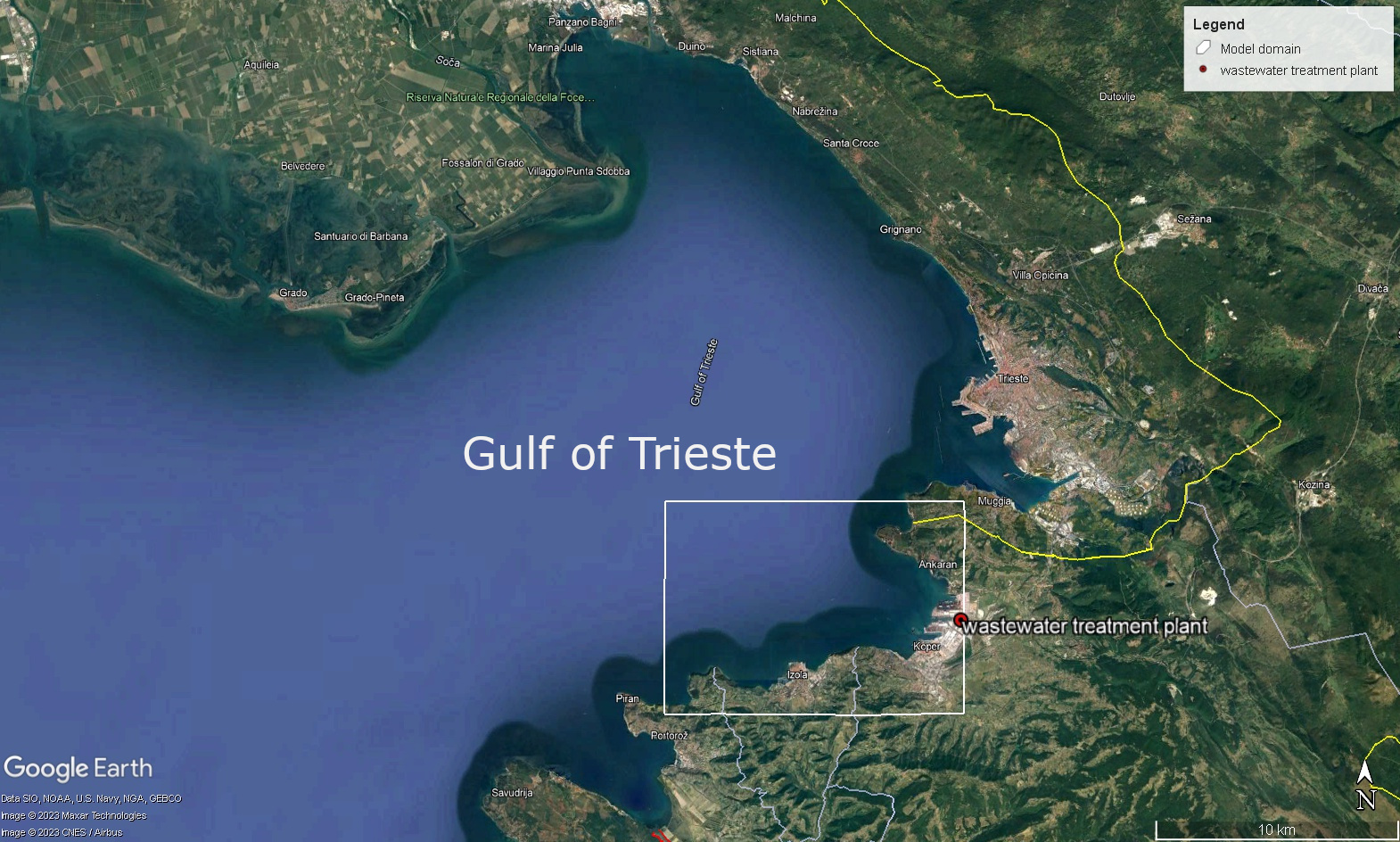 Figure 2 - The location of the sewage treatment plant Figure 2 - The location of the sewage treatment plant |
Objectives, interest and expected benefits for the Copernicus Marine Service and support to EU Policy and Directives:
Our overall objective is to provide marine data and services to enable marine policy implementation, support Blue growth and scientific innovation in northern Adriatic Region. Data and developed use cases could serve as pilots for a future continuous coastal marine surveillance, from the high seas to the coast. Furthermore, the development of exemplary use cases of coastal marine monitoring activities will be supporting the successful implementation of EU environmental directives at regional, national, and international level. The models of the Northern Adriatic area will identify gaps and bottlenecks to be overcome by integrated service from the high seas to the coast.
Links to relevant policies:
Maritime transport: https://www.gov.si/en/policies/transport-and-energy/maritime-transport/
Bathing waters: http://kos.arso.gov.si/en/content/bathing-water-quality-costal-zones-7
Marine protected areas: http://kos.arso.gov.si/en/content/protected-areas-3, https://www.cbd.int/doc/world/si/si-nbsap-01-en.pdf
Copernicus Marine Use Case 1
The results of our numerical model can provide valuable information that can be used to support safer and more ecological marine navigation by optimizing routes, reducing fuel consumption and emissions, improving safety, and responding more effectively to pollution events:
● The numerical model will provide accurate and reliable information about the direction and strength of sea currents, which can help ship operators plan their routes more efficiently and avoid areas where currents are strong or counteract the desired direction of travel.
● Using the information provided by the numerical model, ship operators can optimize their routes to take advantage of favorable currents, which reduces emissions.
● Our numerical model can help identify potential hazards to shipping, such as strong currents, and warn ship operators in a timely manner, increasing the safety of shipping.
● In the event of a marine spill, numerical model can help predict the trajectory of the spill, considering the effects of currents and winds. This information will help Civil protection Service and authorities to successfully limit the ecological consequences or catastrophes.
● The numerical model will help improve our understanding of the marine environment by providing insights into the dynamics of ocean currents and their interaction with the broader marine ecosystem.
● Numerical model could help us to predict future directions of climate change impacts in order protect coastal urban areas at one side and marine / coastal ecosystems on the other side.
● The model results will be used in search and rescue operations.
Copernicus Marine Use Case 2
The results of our coastal numerical model will support marine pollution monitoring in several ways:
● By simulating the movement of pollutants in the sea, the model can predict where they are likely to move and how long it will take them to reach a particular area. This can help responsible authorities anticipate and prepare for potential pollution events.
● The model will contribute to a better understanding of the processes in the coastal sea that control the transport, mixing, and fate of pollutants.
● The model can be used to evaluate the effectiveness of various management strategies to reduce or mitigate pollution.
● The models will be used to identify sensitive marine areas that are particularly vulnerable to pollution.
● The model will be used to monitor the condition of the sea over time, which can help identify changes or trends in pollution levels.
The results of the coastal numerical models that we will develop and deliver, will contribute to objectives of Copernicus Marine Services, namely to the extension of marine data and services of Northern Adriatic Area, which is utmost a necessary case study, due to its geographical position and biodiversity. This case study will enable sustainable marine policy implementation: it will contribute to national and regional implementation of EU Blue Growth, Biodiversity strategy for 2030, European Green Deal objectives. Al global level, the aims will contribute to the implementation of SD 13 Take urgent action to combat climate change and its impact, and SD 14 Conserve and sustainably use the oceans, seas, and marine resources for sustainable development.
On regional level we will provide valuable information to the relevant agencies (Slovenian Environment Agency, National Laboratory of Health, Environment and Food) and enable informed decisions about marine pollution management and protection. Our numerical model will help support the implementation of the Marine Strategy Framework Directive (MSFD) by assessing the state of the marine environment by simulating the movement of pollutants in the sea and predicting the potential impacts of various human activities on the marine environment.
The results of the model will be made freely available to the public.