 NIB - MORSKA BIOLOŠKA POSTAJA PIRAN
Boris Petelin


Dr. BORIS PETELIN
Research Associate
![]()
Telephone:
+386 (0)5 9232 907
E-mail address:
This email address is being protected from spambots. You need JavaScript enabled to view it.
Areas of interest:
Numerical modeling of coastal waters dynamics
Quality control of data obtained by measurements at the sea
Spatial-temporal data mining of measured oceanographic data

SHORT CV
PhD Boris Petelin, Civil engin. graduate:
• 2014 – PhD Computer and Information Science, University of Ljubljana, Faculty of Computer and Information Science
• 1995 – MSc Computer and Information Science, University of Ljubljana, Faculty of Computer and Information Science
• 1984 – BSc Civil Engineering, University of Ljubljana, Faculty of Civil and Geodetic Engineering

COLLABORATIONS
Currently I participate in many national and international projects, from which are the most important:
• MyOcean (2009-2012), MyOcean2 (2012-2014) and MyOcean follow-on (October 2014 - March 2015) are the projects funded by the EU Seventh Framework Programme (FP7 2007-2013) and Horizon 2020 (EU Research and Innovation Programme 2014-2020). Their objective is to define and establish a coherent and comprehensive pan-European capacity for monitoring and forecasting processes in the oceans. Different areas of application may benefit from the activities of these projects: maritime security, oil spill prevention, marine resources management, climate change, seasonal forecasting, coastal activities, water quality and pollution. The main role of the NIB-MBS in these projects is as follows:
o Assessing the usability of the products of aforementioned projects
o Providing the data necessary for the validation of certain MyOcean products – especially the numerical model for the Mediterranean Sea (Mediterranean ocean Forecasting System – MFS). For this purpose we are daily sending the measurements of the oceanographic buoy Vida and the results of our numerical model, which covers the area of northern Adriatic (North Adriatic Princeton Ocean Model – NAPOM) (see Figure 1).
o Maritime security and oil spill prevention - predicting the spread of oil slicks in the Slovenian sea with the help of numerical models NAPOM (NIB-MBS) and NAFTA (University of Ljubljana, Faculty of Civil and Geodetic Engineering)
o The development of oceanographic numerical models to study the dynamics of coastal waters (northern Adriatic Sea, Gulf of Trieste, etc.) (see Figure 2)
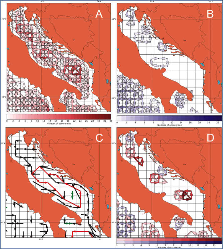
o The spatial-temporal data mining of MyOcean products (Figure 3)
• SeaDataNet (2006-2011) and SeaDataNet2 (2012-2016) are the international oceanographic projects whose main objective is to enable to the scientific community the access to historical data sets, which are located in the national data centers. The task of NIB-MBS under the aforementioned projects is to provide the metadata that describe the data held by NIB-MBS, as well the descriptions NIB-MBS research programs, projects, cruises with the research vessel and oceanographic buoy. On the other hand, NIB-MBS also provides access to the data described by the metadata themselves.

FIELD OF RESEARCH
Working area (physical oceanography, spatial-temporal data mining of the oceanographic data)
Research:
• numerical modeling of dynamics of coastal waters dynamics
• processing and ensuring the quality control of data obtained by the measurements at the sea
• spatial-temporal data mining of measured oceanographic data and the results of numerical models
Figure 1. The validation of the oceanographic numerical model Mediterranean Ocean Forecasting System (MFS) using the data of oceanographic buoy Vida and the numerical model North Adriatic Princeton Ocean Model (NAPOM)
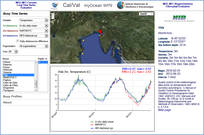
Figure 2. The topography of oceanographic numerical model North Adriatic Princeton Ocean Model (NAPOM)
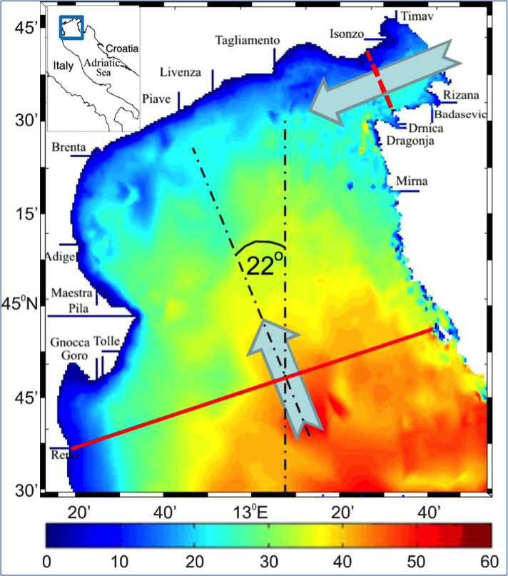
Figure 3. Typical paths and cycles in the surface velocity field of the oceanographic numerical model Mediterranean Ocean Forecasting System (MFS) in the Adriatic Sea

SELECTED (NEWER) PUBLICATIONS
1. PETELIN, Boris, KONONENKO, Igor, MALAČIČ, Vlado, KUKAR, Matjaž. Multi-level association rules and directed graphs for spatial data analysis. Expert systems with applications, ISSN 0957-4174. [Print ed.], 2013, vol. 40, issue 12, str. 4957-4970. http://dx.doi.org/10.1016/j.eswa.2013.03.004, doi: 10.1016/j.eswa.2013.03.004. [COBISS.SI-ID 2761807]
2. MALAČIČ, Vlado, PETELIN, Boris, VODOPIVEC, Martin. Topographic control of wind-driven circulation in the northern Adriatic. Journal of geophysical research, ISSN 0148-0227, 2012, vol. 117, št. C06032, str. 1-16, doi: 10.1029/2012JC008063. [COBISS.SI-ID 2595663]
3. ŽAGAR, Dušan, RAMŠAK, Vanja, LIČER, Matjaž, PETELIN, Boris, MALAČIČ, Vlado. Uporaba numeričnih modelov ob razlitjih nafte na morju = Application of numerical models of oil spills in the sea. Ujma, ISSN 0353-085X, 2012, št. 26, str. 168-174, ilustr., graf. prikazi, zvd. http://www.sos112.si/slo/tdocs/ujma/2012/168.pdf,http://drugg.fgg.uni-lj.si/4055/. [COBISS.SI-ID 2678351]
 Link to COBISS, a Slovenian database containing all my publications